Singapore (island)
Found in 207 Collections and/or Records:
The mouth of S[inga]pore River, 1890 - 1899
267 x 206 mm. A view looking out towards the harbour from the Cavenagh Bridge with sampans loaded with goods entering the river from the port. A photograph taken before the construction of the Anderson Bridge in 1910.
The North Bridge, Singapore, 1908-12
From Boat Quay.
The Padang, with the War Memorial in foreground, 1982
Singapore, including its 50-odd offshore islands and islets has a land area of 617.8km. Its population of 2.4 million comprises 77 per cent Chinese, 15 per cent Malays, 6 per cent Indians, and 2 per cent of persons of other ethnic groups.
The pace of development has been rapid, especially in the last decade, and the people live in well-designed modern homes with ample educational, recreational and social amenities.
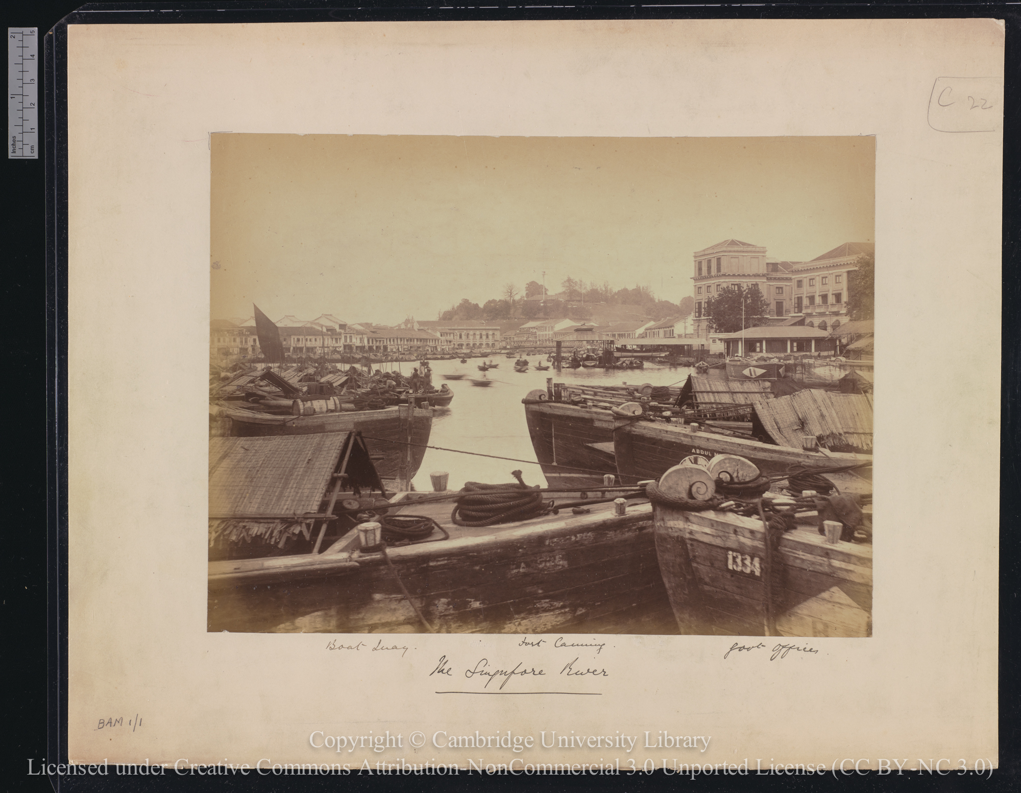
The Singapore River, 1880 - 1889
The Singapore River and Shenton Way, 1982
Singapore, including its 50-odd offshore islands and islets has a land area of 617.8km. Its population of 2.4 million comprises 77 per cent Chinese, 15 per cent Malays, 6 per cent Indians, and 2 per cent of persons of other ethnic groups.
The pace of development has been rapid, especially in the last decade, and the people live in well-designed modern homes with ample educational, recreational and social amenities.
The Victoria Memorial Hall, Singapore [? 1960s], 1960 - 1969
139 x 194 mm. A view from a building on the far side of the river looking across towards the Victoria Memorial Hall and the War Memorial obelisk, with the river and part of the Anderson Bridge in the foreground.
Tiger Temple, Race Course Road, Singapore, 1930 - 1939
82 x 115 mm. A view showing the front façade of the temple, with tigers painted on the eaves and two statues of tigers flanking the entrance.
Towards the R.A. are stationed. On this side of the water is Mount Parma - wooded, 1908-12 - 1908
Landscape format. In foreground is Singapore River - nearly all Chinese boats.
Typical government low-cost flats built by the Housing and Development Board, 1982
Singapore, including its 50-odd offshore islands and islets has a land area of 617.8km. Its population of 2.4 million comprises 77 per cent Chinese, 15 per cent Malays, 6 per cent Indians, and 2 per cent of persons of other ethnic groups.
The pace of development has been rapid, especially in the last decade, and the people live in well-designed modern homes with ample educational, recreational and social amenities.
University of Singapore, 1966
A photograph of the University of Singapore. The University of Malaya was founded in Singapore in 1949 by the amalgamation of Raffles College and the King Edward VII College of Medicine, and a Kuala Lumpur campus followed later. In 1962 the University of Malaya and the University of Singapore were separated. In 1980 the National University of Singapore was created by the amalgamation of the University of Singapore and the Nanyang University. Photograph probably by Ian Maxwell.
Unloading earthenware pots, Kallang Basin, Singapore [? 1960s], 1960 - 1969
191 x 138 mm. Showing moored boats, with pots stacked in the compound in the foreground.
Victoria Theatre and Memorial Hall, Singapore [circa 1967], 1967
89 x 142 mm. General view of main façade.
Victoria Theatre and Memorial Hall, Singapore [circa 1967], 1967
89 x 142 mm.
View from Boat Quay, Singapore, 1908-12
[View across Chinese boats].
View from Clock Tower, Victoria Memorial, Singapore, 1908-12 - 1908
Landscape format. Fort Canning with lighthouse / Govt House / Museum / Hotel de L' Europe. (Fisher).
View from the Clock Tower : Victoria Memorial, 1908-12 - 1908
Landscape format. Looking nearly due south. Dutch Island in the distance. Looking nearly due south / The Master Attendants Office (Harbour Master) / Post Office / Club. In the distance is the Dutch Island : the ornate building on the right of roadway is the Hong Kong and Shanghai Bank. (Fisher).
View from the Clock Tower, Victoria Memorial, Singapore, 1908-12 - 1908
Landscape format. The nearer end is the Singapore Cricket Ground with pavilion : at distant end is the Eurasian Recreation Club : on the left is St Andrew's Cathedral.
View from the Clock Tower, Victoria Memorial, Singapore. The trees on the right are Angsena, planted about 1892. All this is disclaimed, 1908-12 - 1908
[No print]. Missing.
View from the sea side, 1900
273 x 211 mm. A view from the harbour looking towards the Collyer Quay waterfront, with a sampan loaded with sacks in the foreground and boats and lighters moored near the shore. Johnston's Pier is at the extreme right of the print.
View from the window of the Singapore Club, 1920 - 1929
165 x 115 mm. A view from the Singapore Club (which occupied rooms in the Exchange Building) looking down onto Fullerton Square and along Battery Road. Immediately opposite is a part of the offices of the Hong Kong and Shanghai Banking Corporation and next to this, largely obscured by a tree, the Medical Hall founded in 1882.
View of Keppel Harbour, Singapore, with the tin smelting works, the largest in the world, 1890 - 1899
269 x 209 mm. A view from Mount Faber looking across St James and New Harbour towards Pulau Brani, with a Malay village in the foreground and the chimneys of the tin smelting works (opened in 1890) rising from behind the trees in the distance. Better known as New Harbour, it is located south- west of the town and was surveyed by Henry Keppel who in 1848 made repairs there to his ship the Meander. Its importance was largely eclipsed by the growth of the Tanjong Pagar Docks.
View of Singapore, 1908-12
Including Victoria Memorial Building : view from harbour taken on the way to the N.D.L. steamer in the roads.
View of Singapore, 1908-12
Landscape format. Including Victoria Memorial Building : view from harbour taken on the way to the N.D.L. steamer in the roads.
View of Singapore from G. Panti, Johore [i.e. Gunung Panti, Johor], 1930
Glass and film negatives
View of Singapore from G. Panti, Johore [i.e. Gunung Panti, Johor], 1930
Glass and film negatives