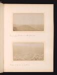
Molai (Μολάοι) and plain of Leukae (ancient Λεῦκαι)
Scope and Contents
View taken from a height, looking down on the town of Molai (Μολάοι) and the plain beyond.
See Wace and Hasluck, "This is without doubt the fertile plain that stretches south-east of Mount Kourkoula. Its name is not due to the colour of the soil, which is red, but probably to the fact that poplar trees grew here. The plain is very rich and grows corn, wine, olives, and figs in abundance. It is drained by a natural subterranean channel (Katavothra) to the north near the village of the same name, and to the west by a stream that runs into the sea north of Xyli. In addition to the village of Katavothra there are to the south, the three villages of Sykea., Pheniki, and Kalyvia and to the north the hamlet of Pakia and the small town of Molai, the modern centre of the eparchy of Epidaurus Limera. At Molai is a small ruined fortof Byzantine or Turkish date, and on the southern peak of Kourkoula a mediaeval refuge-castle with walls of small stones without mortar", Wace, A. J. B., & Hasluck, F. W. (1907). Laconia: II.-Topography. The Annual of the British School at Athens, 14, 161–182, pp. 162-163.
Creator
- From the Fonds: Wace, Alan John Bayard, 1879-1957 (archaeologist) (Person)
Bibliography
Repository Details
Part of the University of Cambridge: Faculty of Classics Archives Repository
Faculty of Classics
Sidgwick Avenue
Cambridge CB3 9DA United Kingdom
+441223 335193
archives@classics.cam.ac.uk